

 360° Virtual Tours
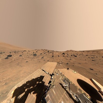
A 360-Degree View of Mars: Spirit and the McMurdo Panorama
What would the landscape look like if you could stand on the surface of Mars and look around you in every direction? The McMurdo Panorama, captured by NASA's Spirit rover as part of the Mars Exploration Rover program, offers one of the most remarkable visual answers to that question. The McMurdo Panorama is a 360-degree view of the Martian landscape created by combining a large number of images captured by the Panoramic Camera (Pancam) aboard NASA's Spirit rover. The panorama provides an exceptionally detailed view of the Low Ridge area, where Spirit spent the southern Martian winter of 2006, as well as the geological formations surrounding the rover.
Spirit's Winter Haven on Mars
From April to October 2006, Spirit remained positioned on a north-facing slope in the area known as Low Ridge. In some of its shorter descriptions, NASA refers to Low Ridge as a “small hill.” However, this should not be interpreted to mean that Spirit was positioned on the summit of a hill or on a completely exposed high point. NASA's more detailed mission descriptions specifically state that Spirit spent several months parked on a north-facing slope. This particular winter location was named “Winter Haven.”
When the panorama is examined visually, the terrain immediately surrounding Spirit can appear somewhat basin-like and partially sheltered because of the shape and elevation of the surrounding landscape. However, NASA does not describe the location geologically as a depression or enclosed basin. Official descriptions primarily emphasize Spirit's position on a north-facing slope at Low Ridge. The equirectangular projection used to display a 360-degree panorama on a flat surface can also significantly distort the appearance of the terrain, particularly toward the lower portion of the image. As a result, when viewed as a flat panoramic image, Spirit's position can appear deeper or more bowl-shaped than the actual terrain geometry would suggest.
Why Was a North-Facing Slope Chosen?
The primary reason Spirit remained at this location for several months was the Martian winter and the decreasing availability of solar energy. Spirit relied heavily on its solar panels to generate the electricity required to operate. As winter progressed in the southern hemisphere of Mars, the Sun's position in the sky changed and the amount of energy that could be generated by the rover's solar panels decreased significantly. For this reason, the mission team positioned Spirit on a suitable north-facing slope. During winter in the southern hemisphere of Mars, the Sun remains toward the northern part of the sky. A north-facing slope therefore allowed Spirit's solar panels to be tilted at a more favorable angle toward the Sun. In effect, the natural slope of the terrain acted almost like a supporting stand for Spirit's solar panels. This positioning allowed Spirit to continue making scientific observations throughout the winter despite extremely limited energy conditions.
How Was the McMurdo Panorama Created?
The McMurdo Panorama is not a single photograph. It is a large panoramic mosaic assembled from numerous individual images captured by Spirit's Pancam at different times and in different directions. Pancam began acquiring the images required for the panorama on Sol 814 of Spirit's mission, April 18, 2006. Because of the rover's limited energy supply during the Martian winter, the images for the main panorama were acquired gradually over a period of several months. Additional images needed to complete portions showing the rover deck were captured on Sol 980, October 5, 2006. A sol, or Martian day, is slightly longer than an Earth day, lasting approximately 24 hours, 39 minutes and 35 seconds. All 13 color filters available on Pancam were used in producing the complete panoramic dataset. The resulting panorama consists of 1,449 Pancam images and represents approximately 500 megabytes of raw image data. Because of its scale and level of detail, the McMurdo Panorama was, at the time it was produced, one of the largest and highest-fidelity panoramic views acquired on the Martian surface by either Spirit or Opportunity.
A 360-Degree Image Months in the Making
One of the most remarkable aspects of the McMurdo Panorama is that it was not captured in a single day. Spirit had only a limited amount of electrical energy available during the Martian winter. The images required for the panorama therefore had to be acquired in small groups, often separated by several Martian days. Acquisition of the main panorama extended over 119 sols. Despite being assembled from images captured over such a long period, the completed panorama maintains a remarkably consistent appearance in terms of lighting and color. This consistency was also aided by the relatively stable atmospheric conditions during winter in the southern hemisphere of Mars.
Why Is It Called “McMurdo”?
The name of the panorama does not come from an official geographical region on Mars. While Spirit was stationed at Winter Haven, the mission team gave nearby rocks, geological features and areas names inspired by terrestrial polar exploration. Many of these names were taken from research locations in Antarctica and exploration sites in the southernmost regions of South America. The name McMurdo refers to the McMurdo region of Antarctica and its famous research station. The choice of name is particularly fitting.Just as researchers in Antarctica spend the harsh winter months working from established research stations under extreme environmental conditions, Spirit remained at its Martian Winter Haven for several months, conserving energy while continuing its scientific observations.
What Can Be Seen in the Panorama?
The McMurdo Panorama is far more than an expansive landscape of reddish and brown Martian terrain. A careful examination reveals numerous geological features surrounding Spirit. The Low Ridge area contains many dark, porous volcanic rocks. Several important landmarks from Spirit's journey across Mars can also be identified in the panorama, including Husband Hill, the El Dorado dune field and the light-toned geological feature known as Home Plate. Husband Hill lies approximately 850 meters from Spirit's Winter Haven position. Tracks left by Spirit during its earlier movements across the surface can also be seen in portions of the panorama. Of particular scientific interest were areas of lighter-colored soil exposed when Spirit's non-functioning right-front wheel dragged across and disturbed the Martian surface. Evidence of sulfur-rich salty minerals was found in some of this exposed material. These findings helped scientists investigate geological processes in Gusev Crater that may have involved water in Mars' past.
Possible Meteorites on Mars
Another intriguing detail in the panorama involves several rocks located near Spirit. Two rocks visible to the right of the center of the panorama appear brighter and smoother than the surrounding dark and porous volcanic rocks. Infrared observations made with Spirit's Miniature Thermal Emission Spectrometer also indicated that these rocks had properties different from those of the surrounding material. NASA scientists considered the possibility that these two rocks could be meteorites. The McMurdo Panorama is therefore not simply a spectacular Martian landscape. It is also an important scientific record in which numerous geological observations can be studied within their broader environmental context.
Is the Panorama True Color?
NASA describes the McMurdo Panorama as being presented in “approximately true color.” This does not mean that the image is an exact photographic reproduction of the colors that human eyes would perceive if a person were standing on Mars. The panorama was produced by combining images obtained through Pancam filters centered at approximately 600, 530 and 480 nanometers, which were used to represent the red, green and blue color channels. According to NASA, this “natural color” representation is the team's best approximation of what a person might see if standing at Spirit's location and looking across the Martian landscape. The brown, reddish, orange and yellowish tones of the surface, together with the characteristic pale reddish-beige appearance of the Martian sky, result from this image-processing approach.
Why Was Spirit Sent to Mars?
Spirit was one of two robotic explorers developed under NASA's Mars Exploration Rover (MER) program. The other rover was Opportunity. One of Spirit's primary scientific objectives was to study Martian rocks and soils in order to investigate the planet's past environmental conditions, particularly geological evidence that could indicate the past presence of liquid water. Spirit's primary surface mission was originally planned to last only 90 sols. The rover, however, dramatically exceeded its expected operational lifetime. On October 26, 2006, Spirit reached its 1,000th sol on Mars. Designed for a mission of roughly three months, Spirit continued conducting scientific investigations on the Martian surface for years. Communication with Spirit was finally lost in March 2010.
The Importance of 360-Degree Imagery in Planetary Exploration
One of the most important characteristics of the McMurdo Panorama is that Spirit's surroundings were documented not merely in one direction but across a complete 360-degree field of view. A conventional photograph records only the area toward which the camera is pointed. A panoramic image, by contrast, allows the rover's position to be understood in relation to its entire surrounding environment. Such imagery provides scientists with valuable information for evaluating the relative positions of rock formations, terrain slopes, geological layers, dune fields and possible routes that a rover might follow. The McMurdo Panorama was therefore more than a visual record. It also served as a scientific and topographic resource that helped the Spirit team assess future scientific targets and possible routes for the rover.
Experiencing the Surface of Mars in 360 Degrees
Presenting panoramic imagery such as McMurdo through modern 360-degree virtual-tour technology provides a different way of experiencing scientific imagery.Instead of viewing Mars as a static photograph, users can change their viewing direction within the panorama, looking left, right, upward and downward to explore the environment surrounding Spirit. This approach also reduces some of the perceptual distortion created when an equirectangular panorama is displayed as a flat image and allows the panorama to be experienced in a way closer to its intended spherical viewing format. As a result, viewers can gain a visual experience closer to standing at Spirit's Winter Haven position and looking across the surface of Mars from the rover's point of view.
The McMurdo Panorama on 360TR
The McMurdo Panorama, originally released by NASA, has been processed by 360TR for presentation in an interactive, web-based 360-degree viewing environment. The purpose of this work is not to alter NASA's scientific imagery or to create a new NASA image, but to adapt the original panoramic material so that users can explore it interactively through modern 360-degree visualization technology. Visitors can therefore virtually look around the Low Ridge – Winter Haven area where Spirit spent the Martian winter of 2006, exploring the rover itself, the Martian surface, nearby rocks and distant terrain features within an immersive panoramic environment. In this sense, the McMurdo Panorama is more than a large photographic mosaic transmitted from Mars. It is an important visual record that allows us to come closer to the experience of standing at a single location on the surface of another planet and looking around in every direction.
Source and Image Credit
Original imagery and scientific data: NASA / JPL / Cornell
Source: NASA Scientific Visualization Studio (SVS)
Title: McMurdo Panorama
NASA SVS ID: 30522
Scientific source: NASA Science – 'McMurdo' Panorama from Spirit's 'Winter Haven'
Spacecraft: NASA Mars Exploration Rover – Spirit
Imaging system: Panoramic Camera (Pancam)
Image acquisition period: April–October 2006
Location: Low Ridge – Winter Haven, Gusev Crater, Mars
360° image processing and interactive presentation: 360TR
Usage and Source Note
The original Mars imagery used in this presentation is credited to NASA/JPL/Cornell. The McMurdo Panorama released by NASA has been processed and presented by 360TR for interactive, web-based 360-degree viewing. The scientific descriptions in this article are based on mission information and image records published by NASA.
Historical
Venue Features
Activities
Similar places
Similar places, nearby places, and related routes are listed here as modular panels.
Nearby places
Similar places, nearby places, and related routes are listed here as modular panels.
Related routes
Travel plans that include this tour as a stop are listed here.
No matching content is available for this section.
Comments
0Sign in to leave a comment.
Sign inThe comments module is ready at the bottom. Visitor comments will appear here once the content is connected.